The gold prospecting app that strikes gold.

The gold prospecting and metal detecting app with Native LiDAR™ and SiteScan™, mining claims, historic maps back to 1879, property lines and offline maps, all on one map.

Download on the App Store

7 days free, every feature unlocked. Then $8.99/mo or $89.99/yr.

A look inside

Native LiDAR: half-meter bare earth with the most detail possible on your phone, in six looks for different ground
SiteScan: scan any spot into a 3D model and let four reads of the ground show you where to look
Know before you go: find the next spot without asking anyone where they hunt
See through the trees: Ultra 1 meter LiDAR reveals old homesteads and workings under the brush
Historic topo maps: scanned USGS maps from 1879 show the mill, the cabin, and the town that are gone
Every layer, offline: not just the map, LiDAR, claims, property lines, and the rest of the layers all go with you
Log every track: every step and every find saved, so you never cover the same ground twice
All your research, one map: 25+ layers to help you research your next hunt location
Go back in time: historic maps from the late 1800s to 1930 laid over the modern map to find what is not there anymore
Find the pay streak: old mines, geology, soil samples and stream data combined to rank the best ground
See what others are pulling out: finds, photos, and notes from prospectors and detectorists nearby
Keep a record of every find: log gold, coins, and relics with weight, notes, and coordinates

Built for prospectors and detectorists

Native LiDAR™

Our newest way to see the ground. The bare earth at half-meter detail, drawn live on your phone instead of served as a flat picture, so you can tilt it in 3D and tune it to your eye. Six looks built for different ground: Polaris, Polaris Ridge, Nova, Eclipse, Zenith and Horizon. Brightness, contrast and depth sliders on every one. Benches, old channels, diggings, ditch lines and homesteads stand out as shapes you can recognize. Comes with your offline downloads. Available in California, with more states coming soon.

SiteScan™

Place a square on any spot and scan it into a 3D model you can turn, tilt and study. Four reads of the ground light up what matters: Workings for ground that has been dug before, Flow Path for where water has moved, Drift for where heavy material travels downhill, and Traps for the places it comes to rest. Tap a result to see why it stands out, long press to drop a pin, and save scans to come back to. Works anywhere Native LiDAR™ is available.

Ultra 1m LiDAR

See what satellite imagery misses. A bare-earth hillshade built from 1-meter USGS 3DEP data reveals the ground's history: old placer cuts, hydraulic pits, tailings piles, ditch lines, and water races invisible from the surface. It is lit so linear features like ditch lines and water races show whichever way they run. Live for California, Oregon, Washington, Idaho, Nevada and Arizona, with more states on the way. It draws only where one-meter data exists.

How to read LiDAR for gold

Historic Topo Maps

Scanned USGS topographic maps going back to 1879, laid over the modern world with an opacity slider so you can fade between then and now. Find the mill, the cabin, the wagon road, and the townsite that vanished a century ago. Three era layers: Oldest (1880s–1930s), Classic (1900s–1940s), and Detailed (1930s–1940s). Covers the entire lower 48.

Maps Built for Finders

Mapbox satellite, topo, geology, and public-lands layers. See claims, property lines, and access. Drop pins on cuts, riffles, foundations, and old workings.

AI Terrain Analysis

Trained strictly for gold prospecting. Snap a photo of a creek, cut bank, or hillside — get a 0–100 score with confidence level. The model identifies rock types, calls out mineral indicators (iron staining, quartz veins, black sand), reads water flow for gold trap potential, names the deposit type (placer, alluvial, hardrock, eluvial), and tells you where in the frame to start sampling. Plain-English explanations included.

Coin & Relic ID

Photograph a coin, button, buckle, nail, or anything else you pull out of the ground and get an identification: what it is, the years it was made, what it's made of, and the history behind it. Built to be honest about uncertainty — when a date isn't legible in the photo, it says so and tells you where to look instead of guessing. It never gives a dollar value or an appraisal. Every result saves to your device, so the finds add up into a record of what you've dug.

GoldBot

Your AI prospecting buddy. Ask about geology, gear, technique, panning, sluicing, or whether that black sand is worth a second look. Trained on 30+ years of placer and lode prospecting knowledge — not search engines. It keeps one running conversation that follows you to a new phone and survives a reinstall, so you never repeat yourself, and you can start fresh any time with New chat.

A Profile That Shows What You've Found

Record routes, mark finds, log your hours. Plus a private gold log: every find with weight (grams or ounces), location, and notes — pinned on your map, never public. Your profile carries a backdrop and photo, your region and main interest, your level (1 to 25), your gold total and your stats, with posts, saved posts, finds and pins one tap away. Earn XP and badges for finds, analyses and posts.

Tips & News

Curated guides for beginners, deeper field technique for veterans, and news from the prospecting world. Hand-picked, no algorithmic clutter.

A Community That Gets It

Share finds, follow people who've been working their patches for decades, swap technique. Prospectors and detectorists welcome. Moderated to keep it useful.

Yours to Keep

Locations and finds are private by default. Share what you want, hide what you don't. Honey holes and permission spots stay yours.


25+ map layers, with more coming

Native LiDAR, historic topo, mining claims, parcels and land status, all on one map.

  • Native LiDAR™

    Half-meter bare earth drawn live on your phone, with six looks and full 3D, plus SiteScan™ for a 3D read of any spot.

  • Ultra 1m LiDAR

    Bare earth relief that strips the tree canopy off and shows old workings as shapes in the ground.

  • Historic USGS Topo

    Scanned sheets back to 1879, carrying mines, ditches and camps that no modern map shows.

  • Mining Claims

    Active and closed claims drawn as boundaries, refreshed every night.

  • Property Lines

    Parcel boundaries across 2,000+ counties in the lower 48, so the edge between public and private ground is a line you can see.

  • Historic Mines

    Documented mine sites with the commodity, the deposit type and how far each one was developed.

  • Public Lands

    Federal, state and local ground drawn unit by unit, with the restrictions that sit on top.

  • Geochemistry

    Stream-sediment, soil, rock and pan-concentrate samples with the full assay, colored by gold tier.

  • Rock Types

    Surface geology units: the contacts, faults and intrusives that decide where gold sits.

  • Streams and Rivers

    Tap any waterway for whether it runs year round, its size class and its average annual flow.

  • Lakes and Ponds

    Name, surface acreage and water body type, with river channels drawn through reservoirs.

  • Ghost Towns

    Historical towns, camps and forts, with a researched history on every card.

  • and 15 more

See all layers

The map works where there's no service

Canyons, back roads, the last ten miles of dirt before the creek. Download the ground you plan to work while you still have signal, and in the field the map runs off your phone with no service at all. Almost every layer comes with it, not just the basemap.

  • Satellite imagery
  • Native LiDAR™ and SiteScan™
  • Ultra 1m LiDAR
  • All three historic topo bands
  • Property lines
  • Active and closed claims
  • Public lands
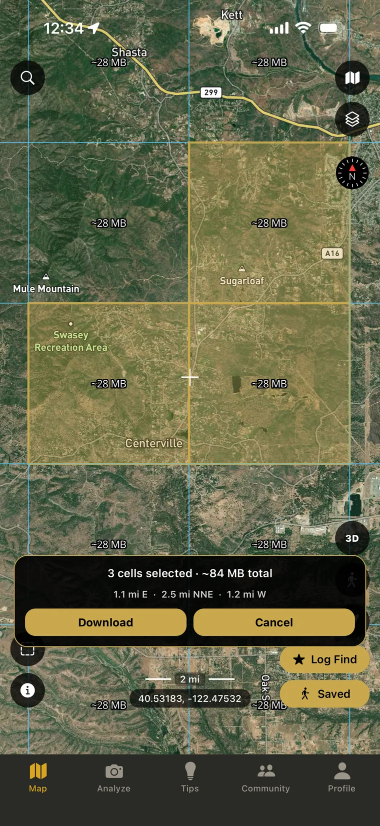
The download grid over satellite imagery with three cells highlighted, the panel showing three cells selected and about 84 MB total
Select the cells covering the ground you plan to work and hit the download button.

Read the offline maps guide

How it works

  1. 1

    Scout

    Browse the map, find a creek, an old homestead, or a likely site. Save the area for offline.

  2. 2

    Read

    At the spot, snap a photo of the terrain. Get a 0–100 score and reasoning you can actually learn from.

  3. 3

    Find

    Work the spot. Pan, sluice, dig, or swing the coil — the reason you came out.

  4. 4

    Log

    Mark finds, track your route, share what you want with the community.

Try the whole thing free for 7 days.

Every feature unlocked for 7 days, no card needed: Native LiDAR, SiteScan, every map layer, AI analysis, GoldBot and offline maps. When the trial ends, keep going with Pro or stay on the free map.

$8.99/month or $89.99/year
Save $17.89 with annual

Pro is a subscription billed through your Apple ID and renews until canceled. Manage or cancel any time in your Apple ID settings.

About Gold Prospector

Built by a prospector for prospectors. Three decades of weekends working creeks with a pan, eight years swinging a detector, and a stubborn belief that the prospecting community deserves better tools and a real place to share what they find.

Read the full story

FAQ

How does the free trial work?

All features unlocked for 7 days, and you do not enter a card to start. When the trial ends you choose: subscribe to Pro through your Apple ID, or keep using the free map, GPS, pins, find log, trail tracking and community. Nothing is charged unless you subscribe.

What does it cost after the trial?

$8.99 per month or $89.99 per year. The annual saves you $17.89.

What devices does it run on?

iPhone (iOS 16+). Android is on the roadmap.

Does it work without cell service?

Yes. Download the area before you head out, then tap the saved map in Offline Maps to activate it. A banner shows which area is live, and the map draws only from what you downloaded. Tracking and logging work offline too. Full instructions here.

Will it tell me where to find gold or relics?

No app can do that. We give you better tools to read the land — actually making the find is still on you.

What about the coin or relic I just found?

Coin & Relic ID identifies what you found, what it's made of, and roughly when it's from, right from a photo. It won't tell you where to dig, but once you've got something out of the ground, it'll tell you what it is.

Where can I prospect or detect?

Prospecting: public lands open to mineral entry, and any claim you legally hold. Detecting: lands where you have permission. Rules vary by state — never on federal park land, often restricted on archaeological sites. Always know the local rules.